
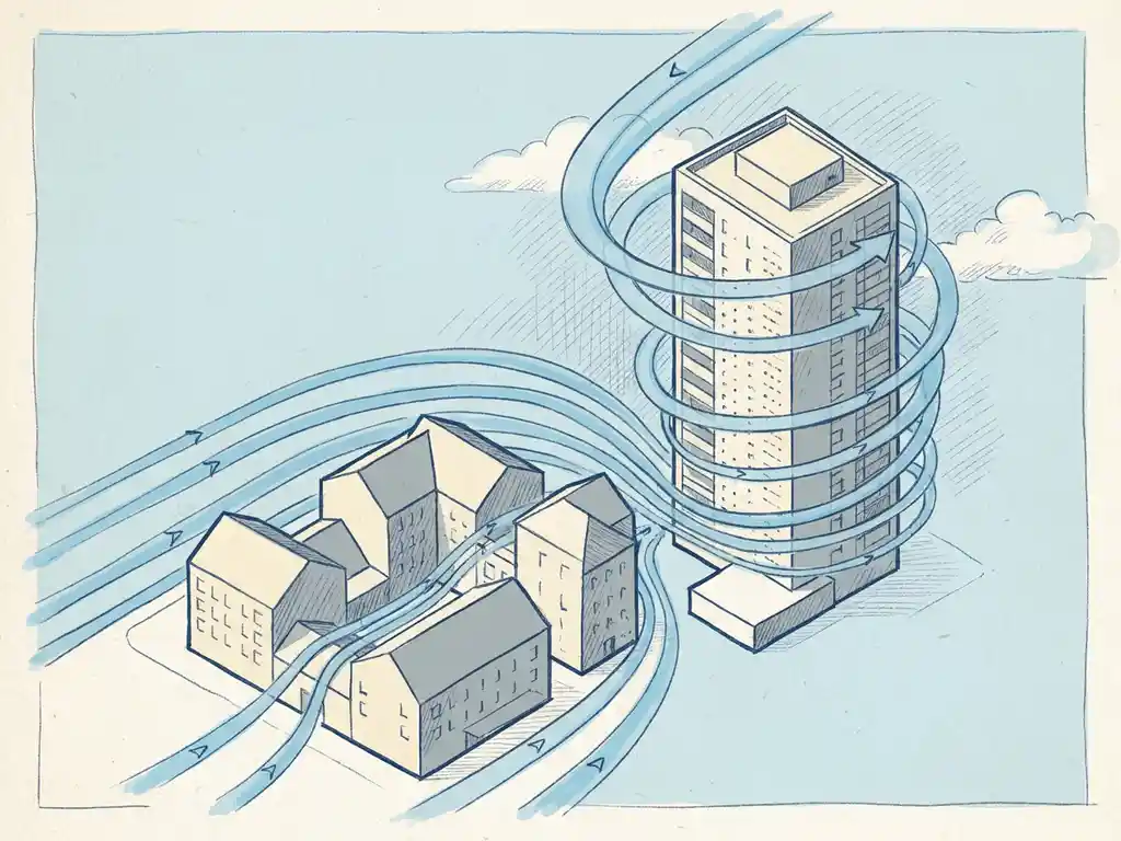
High-rise buildings create stronger wind effects at street level because they intercept fast-moving air from higher in the atmosphere and redirect it downward toward pedestrians. Low-rise buildings stay mostly within the slower, sheltered zone close to the ground, so the wind they disturb is already relatively weak. The taller a building, the more it reaches into genuinely fast airflow and pushes it where people walk. The sections below unpack exactly why that happens and what it means for building design.
What is the atmospheric boundary layer and how does it affect buildings?
The atmospheric boundary layer is the lowest portion of the atmosphere where wind speed increases with height due to friction with the ground. Near the surface, buildings, trees, and terrain slow the wind down considerably. Higher up, that friction fades and wind moves much faster. This gradient is what makes building height so significant for wind behavior.
At ground level in a dense urban environment, wind speeds are often a fraction of what you would measure at 60 or 100 metres above the rooftops. A low-rise building of, say, five storeys sits almost entirely within this sheltered zone. A 100-metre tower punches well above it, intercepting wind that is moving two or three times faster than what pedestrians feel on a calm street. That fast air has to go somewhere, and it typically goes down.
Engineers model this gradient using what is called a logarithmic atmospheric boundary layer profile. In the Netherlands, this profile is standardised in NPR 6097:2006, which forms the meteorological foundation for wind assessments under NEN 8100. Understanding where a building sits within this gradient is the starting point for any serious wind study.
What wind phenomena are unique to high-rise buildings?
High-rise buildings generate several wind phenomena that low-rise structures simply do not produce at meaningful intensity. The most significant are downwash, corner acceleration, and channelling between towers. Each of these can push wind conditions at street level from comfortable to genuinely hazardous.
Downwash occurs when fast-moving air hits the windward facade of a tall building and has nowhere to go but down. The taller the building, the faster the incoming air and the more forceful the downward stream. A building that is more than twice the height of its surroundings is particularly prone to generating downwash that reaches pedestrian level.
Corner acceleration happens because air flowing around a building compresses as it squeezes past the edges. This is similar to what happens when you put your thumb over a garden hose. The result is that wind speeds at building corners can be significantly higher than the undisturbed wind approaching the facade.
Channelling occurs when two tall buildings stand close together, forming a corridor that funnels and accelerates wind between them.
How does building shape influence wind flow patterns?
Building shape has a direct effect on how wind flows around and past a structure. A broad, flat facade perpendicular to the prevailing wind acts like a wall, forcing air to split and accelerate around the edges. A tapered, rounded, or angled form lets wind slide past more smoothly, reducing the intensity of corner acceleration and downwash.
Setbacks, where the upper floors of a building step back from the lower floors, are one of the most effective shape-based tools for managing wind at street level. The rule of thumb is a minimum setback depth of five metres for a building of around 100 metres tall. The roof level of the setback itself is not a comfortable place to be, as it sits directly in the downward flow, but the street below benefits from the reduced exposed facade.
Passages and openings through a building at ground level are another shape factor that often gets underestimated. An opening aligned with the dominant wind direction creates a pressure shortcut that accelerates flow through the gap. If a passage is unavoidable, making it as narrow as possible limits this effect. The same logic applies to open facades on squares: when more than 25% of the windward face of a square is open, the risk of wind discomfort increases sharply.
Orienting the narrowest facade of a building toward the prevailing wind, rather than the broadest one, is one of the simplest and most effective design decisions available at the early planning stage. This is where wind engineering input during concept design pays off most, because changes at that stage cost far less than corrections during detailed design.
When does wind around a building become a safety or comfort concern?
Wind around a building becomes a comfort concern when pedestrians regularly experience speeds above 5 m/s for activities like walking, or lower thresholds for sitting and relaxing. It becomes a safety concern when speeds exceed 15 m/s with a probability above 0.30% per year, which NEN 8100 classifies as unacceptable regardless of location or use.
In practice, the distinction between comfort and safety matters for how you respond. Comfort issues, classified as NEN 8100 classes C through E, can often be addressed through design adjustments such as setbacks, screens, or planting. Safety issues, where conditions are classified as dangerous, require more fundamental changes to building massing or layout.
Some locations are structurally more exposed. Bridges, open riverbanks, and areas downwind of low industrial buildings are all contexts where wind arrives with little prior obstruction. The area around Rotterdam’s Lloyd Tower is a well-documented example: despite the tower reaching only 70 metres, its position means southwest winds travel across low warehousing and the river without interruption, generating downwash that reaches pedestrian level with unusual force. That kind of context is not always obvious from a site plan alone, which is why wind assessments consider the full surrounding environment, not just the building in question.
Street geometry also plays a role. A street-width-to-building-height ratio below 0.35 means most wind clears the rooftops and stays above street level. A ratio above 0.65 pushes most flow over the buildings entirely. It is the middle range, between 0.35 and 0.65, where conditions are most variable and where careful assessment adds the most value.
How do engineers assess wind flow differences between building types?
Engineers assess wind flow differences between building types using two main methods: physical wind tunnel testing and CFD (Computational Fluid Dynamics) simulation. For individual buildings and smaller developments, both methods are viable. For large-scale urban areas covering multiple blocks or an entire district, CFD is the practical choice because a physical model at that scale is not feasible.
A CFD assessment starts with a 3D model built from geodata, including existing and permitted buildings in the surrounding area. The air volume above and between the buildings is divided into a computational mesh of cells, with finer resolution close to surfaces and coarser resolution further away. Simulations are then run for multiple wind directions, and the results are processed into colour-coded maps showing wind speed and comfort class across the area.
The meteorological input matters as much as the geometry. In the Netherlands, assessments under NEN 8100 use wind statistics from NPR 6097:2006, which covers the period 1963 to 2002. More recent datasets, such as the Dutch Offshore Wind Atlas (DOWA), offer higher resolution and seasonal breakdowns, and are increasingly used alongside the statutory dataset. For projects outside the Netherlands, the Lawson criteria mainly apply, and the meteorological input shifts accordingly.
One practical benchmark for scale: a city-wide study of Rotterdam’s core area required a computational mesh of more than 583 million cells, roughly 20 to 30 times larger than a typical single-building study. That gives you a sense of how differently the assessment process scales between a single high-rise and a full urban district.
How Actiflow helps with wind flow assessment for your building project
We specialise in exactly this type of assessment, from single high-rise buildings to city-wide masterplans. Our team combines deep CFD expertise with direct knowledge of NEN 8100, Lawson criteria, and the specific requirements of Dutch and international municipalities. Here is what we offer:
- Pedestrian wind comfort assessments using CFD simulation or wind tunnel testing, classified according to NEN 8100 or Lawson criteria depending on your project location
- Wind loading studies for facades and structural elements, providing the data your structural engineer and cladding contractor need
- Large-scale area studies covering full districts or masterplan areas, including the kind of city-wide analysis we carried out for Rotterdam
- Early-stage design input that helps you catch wind problems before they become expensive corrections
- Clear, visual output in the form of colour-coded maps and graphics that you can share directly with clients, planners, and permit authorities
- International project experience across the UK, Gibraltar, the Netherlands, Belgium, and beyond, with familiarity with both NEN 8100 and Lawson frameworks
We are known for moving quickly. For regular clients, we set everything else aside to start the next day if the project demands it. And because we handle the full process from intake to final report, you have one point of contact throughout.
Curious how we can help with wind flow assessment for your project? Contact us and we will be happy to discuss your project and help you find the right engineering solution. You can also learn more about our team and background on our about us page.
