
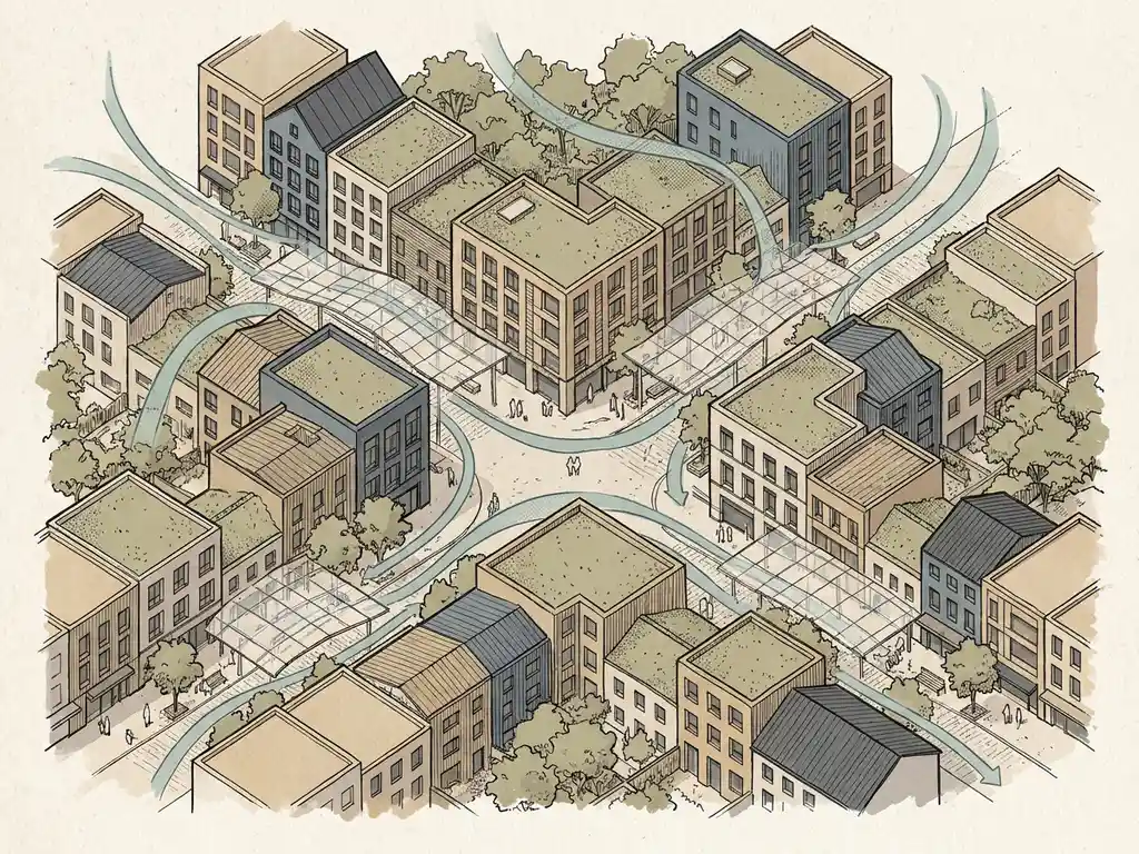
Six urban design features consistently help reduce harmful wind speeds at street level: building clustering, stepped setbacks, podiums and plinths, aerodynamic facade shaping, vegetation, and streetscape barriers. Each works at a different scale, from city block planning down to the pavement in front of your entrance. The sections below explain exactly how each feature works and when to apply it.
How do buildings and street layouts create dangerous wind conditions?
Buildings and street layouts create dangerous wind conditions by accelerating airflow through gaps, around corners, and down tall facades. When wind hits a high-rise, it cannot pass through the structure, so it diverts around the sides and downward toward street level, often reaching speeds two to three times higher than the undisturbed wind above the rooftops. Street geometry amplifies this further.
The most common problem patterns are well established. A building that stands more than twice the height of its immediate surroundings is far more likely to generate wind issues at ground level. Open plazas with more than 25% of their windward facade exposed dramatically increase the chance of wind nuisance. Streets oriented parallel to the prevailing wind direction act as channels, pulling air through at higher speeds than the surrounding area, a pattern sometimes called the canyon effect.
One practical rule of thumb for street geometry is the height-to-width ratio, or H/W. When H/W is below 0.35, most wind reaches the street with little obstruction. Between 0.35 and 0.65, wind is partially intercepted. Above 0.65, most wind is deflected over the roofline rather than down to pedestrian level. Understanding these ratios early in a project gives designers real leverage before layouts are fixed.
What role do building shape and height play in wind speed?
Building shape and height directly determine how much wind is pushed down to street level and how fast it travels there. Tall, broad, flat-faced buildings act like sails, catching the maximum amount of wind and forcing it downward. Taller buildings expose pedestrians to stronger wind simply because wind speed increases with height, and a taller facade channels more of that faster air to the ground.
Shape makes a measurable difference. Round or tapered facades allow wind to flow around and past the structure rather than straight down the face. Placing the narrowest facade perpendicular to the prevailing wind direction reduces the surface area catching the wind and limits downward acceleration. Avoiding wide, flat elevations facing the dominant wind direction is one of the simplest and most effective early design decisions available.
Height differences between neighbouring buildings also matter. When one building is significantly taller than its neighbours, the wind pressure difference between the exposed upper floors and the sheltered lower area creates strong downward currents. Keeping height differences between adjacent buildings to a maximum of around 30% helps prevent this. The so-called Manhattan effect works in the opposite direction: clustering towers of similar height means they shelter each other, reducing the net wind exposure for each individual building and the streets between them.
How do podiums and plinths reduce pedestrian-level wind?
Podiums and plinths reduce pedestrian-level wind by intercepting downward airflow before it reaches the street. A stepped base at the foot of a tall building catches the descending airstream and redirects it horizontally, keeping the strongest gusts above head height. This approach is more reliable than canopies because it addresses the source of the problem rather than just shielding a narrow strip of pavement.
Setbacks work on the same principle. When a building steps back from the street at a lower floor, the roof of that lower section acts as a buffer zone. The practical guideline is a minimum setback depth of around 5 metres for a building of approximately 100 metres tall. One important note: the roof level of the setback itself sits directly in the downward airstream and is unsuitable as an outdoor terrace or usable space. The benefit is at street level, not on the podium roof.
Covered walkways and galleries built into the podium provide direct pedestrian protection and are worth considering where street-level activity is a priority. They need to be at least 5 metres deep to be effective for a building around 100 metres tall. The area immediately beside the gallery, outside the covered section, receives no protection, so the placement of entrances and seating areas relative to the covered zone matters.
Can vegetation and green infrastructure lower wind speeds in cities?
Vegetation can lower wind speeds at street level and meaningfully improve pedestrian comfort, but it works best as a supporting measure rather than a primary solution to serious wind hazards. Trees, hedges, and shrubs create physical resistance that slows airflow and breaks up gusts. In practice, well-placed planting can reduce local wind speeds noticeably, particularly in areas where wind conditions are uncomfortable but not dangerous.
Two limitations are worth understanding. First, deciduous trees lose their leaves in winter, precisely when wind speeds are highest. A row of trees that provides real shelter in summer may offer much less protection in January. Second, trees struggle to establish and grow well in the windiest locations. Research in Rotterdam found that trees in corner flow zones, where accelerated wind wraps around building edges, show measurably worse growth than trees in sheltered spots. Planting in a location with severe wind conditions may not produce the shelter you are counting on.
For areas where wind conditions are genuinely dangerous under NEN 8100 or Lawson criteria, vegetation alone is not sufficient. It works best in combination with structural measures such as setbacks or podiums, and as a way to fine-tune comfort in areas that are already within acceptable wind classes. Strategic placement near seating areas, playgrounds, and building entrances is where green infrastructure adds the most practical value.
What urban furniture and streetscape elements act as wind barriers?
Screens, raised planters, pergolas, and changes in pavement level all act as wind barriers at street scale. Screens are the most direct option: a solid or semi-permeable screen placed on the windward side of a terrace or entrance can redirect airflow and create a sheltered zone. Depressed seating areas, where the floor level drops below the surrounding pavement, use the same logic, placing people below the main airstream.
Screens come with trade-offs. They redirect wind rather than eliminate it, which means the edges of a screen often experience higher speeds than the surrounding area as air accelerates around the obstruction. Poorly placed screens can create new problem spots while solving the original one. Solid screens also raise questions about sightlines and perceived safety, which matters in public spaces. Semi-permeable designs, such as slatted timber or dense planting panels, reduce the edge acceleration effect while still providing meaningful shelter.
The placement of urban functions is itself a form of wind management. Locating playgrounds, terraces, and main building entrances away from the windiest spots on a site, and placing them in naturally sheltered positions such as recessed corners or the lee side of a structure, is sometimes the simplest solution available. A small shift in the position of a terrace or entrance can move it from a class D wind zone to a class B zone without any additional construction.
For a broader overview of how these measures fit into a complete wind engineering approach, the relationship between site layout, building form, and streetscape design is worth understanding as a connected system rather than a set of independent fixes.
When should a CFD simulation or wind tunnel test be used to validate design choices?
A CFD simulation or wind tunnel test should be used when design choices affect wind conditions at pedestrian level and the consequences of getting it wrong are significant, whether for permit approval, occupant comfort, or safety. For individual buildings and smaller masterplans, both methods are viable. For large-scale urban areas covering multiple blocks or an entire district, CFD is the practical choice because physical wind tunnel models at that scale are not feasible.
The right moment to run a simulation is earlier than most teams expect. Wind problems discovered after a building layout is fixed are far harder and more expensive to resolve. A CFD study during the concept or schematic design phase gives you real data to inform decisions about building height, orientation, setbacks, and ground floor uses while those decisions are still open. Waiting until the permit stage means you are validating rather than designing, and any required changes carry a much higher cost.
For projects in the Netherlands, the relevant standard is NEN 8100, which classifies wind conditions from class A to class E based on the exceedance probability of 5 m/s at eye height. For international projects, the Lawson criteria apply the same underlying logic with slightly different thresholds. Both standards require a structured assessment methodology, and both produce outputs that permit authorities expect to see in a specific format. Knowing which standard applies to your project, and which wind data set is required, is worth confirming before commissioning any study.
The Actiflow website provides further context on when each assessment method is appropriate and what the process involves from first contact to final report.
How Actiflow helps reduce harmful wind speeds through smart design
We work with architects, developers, structural engineers, and municipalities to identify wind risks early and translate them into practical design decisions. Our team has over 21 years of experience in fluid dynamics, and we are familiar with the regulatory requirements of municipalities across the Netherlands, Belgium, the UK, and beyond, including the specific expectations around NEN 8100 and the Lawson criteria.
- CFD simulations and wind tunnel testing to assess pedestrian wind comfort and wind loading at any scale, from a single high-rise to a city-wide masterplan
- Colour-coded wind maps and visualisations that are directly presentable to clients, planners, and permit authorities without requiring technical translation
- Design feedback during concept and schematic phases, when adjustments to building orientation, setbacks, and street layout are still straightforward
- Large-scale area assessments, including experience with city-wide studies such as the wind study we carried out for the city of Rotterdam
- Fast turnaround, with a high degree of process automation and, for regular clients, the ability to start the next day if the project timeline demands it
- Advice on mitigation measures, from structural setbacks and podium design to vegetation placement and streetscape adjustments, with clear guidance on what will and will not be effective for your specific situation
Curious how we can help reduce harmful wind speeds in your project? Contact us and we would be happy to discuss your project and help you find the right engineering solution. You can also find out more about our team and approach on our about us page.
